What an agricultural drone survey is
An agricultural drone survey uses a camera or sensor-equipped drone to capture images and measurements of fields, crops and rural infrastructure from the air. Unlike spraying or spreading, nothing is applied, so it sits under a simpler set of rules and is one of the most accessible places for a farm to start with drones. The value is in the data and what it tells you, not in the flight itself.
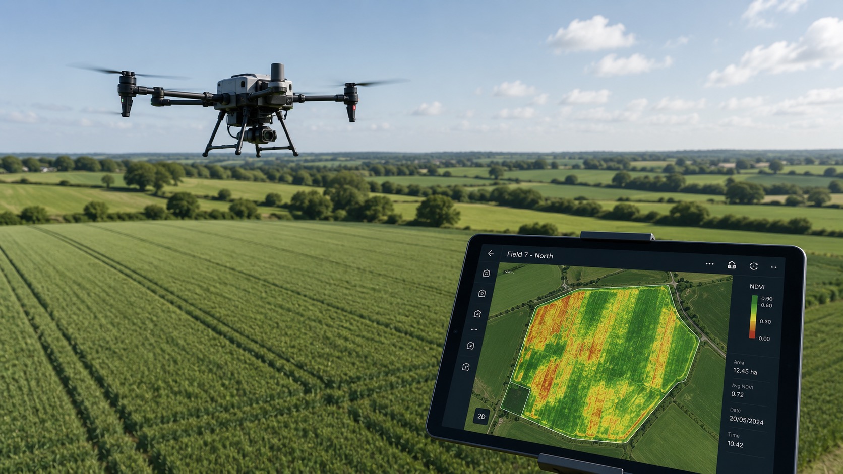
What you actually get
Depending on the sensor and the job, a survey can produce:
- Orthomosaic maps: many photographs stitched into one accurate, measurable image of a field or farm.
- Multispectral or NDVI imagery: crop-health maps that show variation in vigour the eye cannot see, useful for spotting stress, weeds or establishment problems.
- Elevation and contour models: for drainage, run-off and earthworks planning.
- Measurements and counts: areas, distances and feature mapping for records and planning.
Agree up front exactly what you will receive, the resolution, and who owns the data and files.
How farms use the data
Survey data turns guesswork into evidence. Common uses include scouting crops for stress or disease before it spreads, mapping weeds or bare patches to target inputs, planning variable-rate applications, recording field boundaries and drainage, monitoring establishment, and building baseline records for stewardship or planning. Agronomists increasingly use this imagery to make and justify recommendations.
What to check before booking
Ask what outputs you will receive and in what format, the resolution and timing, whether interpretation or agronomy support is included, and who owns the data. Confirm too that the operator holds the right aviation permissions and insurance for the survey area. A strong agricultural survey operator understands the farming question behind the flight, not just the drone.
Surveys versus application work
Because surveys apply no product, they avoid the pesticide rules that restrict drone spraying, which makes them quicker to arrange and lower risk. For many farms a survey is the sensible first step: understand the field, then decide what, if anything, to apply and how. The two often work together, with a survey informing a targeted application.
To go further, see the drone surveys and mapping service page and use the operator directory to find someone who offers it.
Related guides
- Agricultural drone law in the UK: what you can and can't do
- What to ask before hiring a drone operator
- How to become an agricultural drone operator
Useful links
Start with the operator directory, training providers, equipment page and quote request form.
FAQs
What is an agricultural drone survey?
A drone survey captures images and measurements of fields and crops from the air. Nothing is applied, so it carries a simpler compliance profile than spraying. Outputs include orthomosaic maps, NDVI crop-health imagery, elevation models and measurements.
What is NDVI mapping?
NDVI (Normalised Difference Vegetation Index) uses multispectral imagery to show crop vigour and stress that is not visible to the eye, helping you spot problems and target inputs. It is one of the most common outputs from an agricultural drone survey.
What can you do with drone survey data?
Scout crops for stress or disease, map weeds and bare areas, plan variable-rate applications, record boundaries and drainage, monitor establishment, and build baseline records for stewardship or planning.
Do drone surveys need spraying permissions?
No. Surveys apply no product, so the aerial spraying rules do not apply. The operator still needs appropriate aviation permissions and insurance for the survey.
How much does an agricultural drone survey cost?
It is usually priced by area and the outputs you need, so confirm what is included, whether images, maps, measurements or reports. Send the survey area and required outputs for an accurate quote.